Note
This page was generated from examples/notebooks/stare_join.ipynb.
STARE-Based Joins#
[1]:
import starepandas
import geopandas
import datetime
import matplotlib.pyplot as plt
Loading Some Data#
[2]:
cities = ['Buenos Aires', 'Brasilia', 'Santiago',
          'Bogota', 'Caracas', 'Sao Paulo', 'Bridgetown']

latitudes = [-34.58, -15.78, -33.45, 4.60, 10.48, -23.55, 13.1]
longitudes = [-58.66, -47.91, -70.66, -74.08, -66.86, -46.63, -59.62]
data =  {'City': cities,
         'Latitude': latitudes, 'Longitude': longitudes}

cities = starepandas.STAREDataFrame(data)
stare = starepandas.sids_from_xy(cities.Longitude, cities.Latitude, level=26)
geom = geopandas.points_from_xy(cities.Longitude, cities.Latitude, crs='EPSG:4326')
cities.set_sids(stare, inplace=True)
cities.set_geometry(geom, inplace=True)
cities.add_trixels(inplace=True)
[3]:
countries = geopandas.read_file(geopandas.datasets.get_path('naturalearth_lowres'))#.set_crs(4326)
samerica = countries[countries.continent=='South America']
samerica = starepandas.STAREDataFrame(samerica, add_sids=True, level=7, add_trixels=True)

brazil = samerica[samerica.name=='Brazil']
Small Join#
[4]:
geopandas.sjoin(samerica, cities, how='left').head()
/tmp/ipykernel_1001175/189025826.py:1: UserWarning: CRS mismatch between the CRS of left geometries and the CRS of right geometries.
Use `to_crs()` to reproject one of the input geometries to match the CRS of the other.

Left CRS: None
Right CRS: EPSG:4326

  geopandas.sjoin(samerica, cities, how='left').head()
[4]:
| pop_est | continent | name | iso_a3 | gdp_md_est | geometry | sids_left | trixels_left | index_right | City | Latitude | Longitude | sids_right | trixels_right | |
|---|---|---|---|---|---|---|---|---|---|---|---|---|---|---|
| 9 | 44293293 | South America | Argentina | ARG | 879400.0 | MULTIPOLYGON (((-68.63401 -52.63637, -68.25000... | [1831874332805038087, 1831909517177126919, 183... | MULTIPOLYGON (((-68.10744 -55.31801, -67.97225... | 0.0 | Buenos Aires | -34.58 | -58.66 | 2.663379e+18 | POLYGON ((-58.66000 -34.58000, -58.66000 -34.5... |
| 10 | 17789267 | South America | Chile | CHL | 436100.0 | MULTIPOLYGON (((-68.63401 -52.63637, -68.63335... | [1822268999224786951, 1822339367968964615, 182... | MULTIPOLYGON (((-70.49911 -54.87622, -70.66819... | 2.0 | Santiago | -33.45 | -70.66 | 2.723775e+18 | POLYGON ((-70.66000 -33.45000, -70.66000 -33.4... |
| 20 | 2931 | South America | Falkland Is. | FLK | 281.8 | POLYGON ((-61.20000 -51.85000, -60.00000 -51.2... | [1807104534854500359, 1807245272342855687, 180... | MULTIPOLYGON (((-60.67409 -51.68503, -59.57634... | NaN | NaN | NaN | NaN | NaN | None |
| 28 | 3360148 | South America | Uruguay | URY | 73250.0 | POLYGON ((-57.62513 -30.21629, -56.97603 -30.1... | [2632353982198054918, 2661627379775963142, 266... | MULTIPOLYGON (((-55.17662 -32.24790, -55.77960... | NaN | NaN | NaN | NaN | NaN | None |
| 29 | 207353391 | South America | Brazil | BRA | 3081000.0 | POLYGON ((-53.37366 -33.76838, -53.65054 -33.2... | [2749447572509687812, 2796735368597078020, 286... | MULTIPOLYGON (((-53.69934 -4.63080, -61.44765 ... | 1.0 | Brasilia | -15.78 | -47.91 | 2.867415e+18 | POLYGON ((-47.91000 -15.78000, -47.91000 -15.7... |
[5]:
starepandas.stare_join(samerica, cities, how='left').head()
[5]:
| pop_est | continent | name | iso_a3 | gdp_md_est | geometry_left | sids_left | trixels_left | key_right | City | Latitude | Longitude | sids_right | geometry_right | trixels_right | |
|---|---|---|---|---|---|---|---|---|---|---|---|---|---|---|---|
| 9 | 44293293 | South America | Argentina | ARG | 879400.0 | MULTIPOLYGON (((-68.63401 -52.63637, -68.25000... | [1811572950109782022, 1811713687598137351, 181... | MULTIPOLYGON (((-68.10744 -55.31801, -67.97225... | 0.0 | Buenos Aires | -34.58 | -58.66 | 2.663379e+18 | POINT (-58.66000 -34.58000) | POLYGON ((-58.66000 -34.58000, -58.66000 -34.5... |
| 10 | 17789267 | South America | Chile | CHL | 436100.0 | MULTIPOLYGON (((-68.63401 -52.63637, -68.63335... | [1810517418947117063, 1810622972063383559, 181... | MULTIPOLYGON (((-70.49911 -54.87622, -70.66819... | 2.0 | Santiago | -33.45 | -70.66 | 2.723775e+18 | POINT (-70.66000 -33.45000) | POLYGON ((-70.66000 -33.45000, -70.66000 -33.4... |
| 20 | 2931 | South America | Falkland Is. | FLK | 281.8 | POLYGON ((-61.20000 -51.85000, -60.00000 -51.2... | [1807104534854500359, 1807245272342855687, 180... | MULTIPOLYGON (((-60.67409 -51.68503, -59.57634... | NaN | NaN | NaN | NaN | NaN | None | None |
| 28 | 3360148 | South America | Uruguay | URY | 73250.0 | POLYGON ((-57.62513 -30.21629, -56.97603 -30.1... | [2632353982198054918, 2632494719686410247, 263... | MULTIPOLYGON (((-55.17662 -32.24790, -55.77960... | NaN | NaN | NaN | NaN | NaN | None | None |
| 29 | 207353391 | South America | Brazil | BRA | 3081000.0 | POLYGON ((-53.37366 -33.76838, -53.65054 -33.2... | [2643648165638569991, 2643753718754836487, 264... | MULTIPOLYGON (((-53.69934 -4.63080, -61.44765 ... | 1.0 | Brasilia | -15.78 | -47.91 | 2.867415e+18 | POINT (-47.91000 -15.78000) | POLYGON ((-47.91000 -15.78000, -47.91000 -15.7... |
Granule Intersect#
[6]:
fname = '../tests/data/granules/MYD05_L2.A2020060.1635.061.2020061153519.hdf'
[7]:
modis = starepandas.read_granule(fname, add_sids=True, adapt_resolution=True, track_first=False)

trixels = modis.make_trixels()
modis.set_trixels(trixels, inplace=True)

geom = geopandas.points_from_xy(modis.lon, modis.lat, crs='EPSG:4326')
modis.set_geometry(geom, inplace=True)
Geos based intersects test#
[8]:
start = datetime.datetime.now()
b = modis.intersects(brazil.iloc[0].geometry)
print(datetime.datetime.now() - start)
0:00:02.052549
STARE based intersects test#
[9]:
start = datetime.datetime.now()
a = modis.stare_intersects(brazil['sids'].iloc[0])
print(datetime.datetime.now() - start)
0:00:00.141935
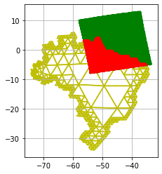
Plot#
[10]:
fig, ax = plt.subplots()
ax.grid(True)

brazil.plot(ax=ax, trixels=True, boundary=True, color='y', zorder=0)
#brazil.plot(ax=ax, trixels=False, facecolor="none", edgecolor='blue', zorder=1)
modis.plot(ax=ax, color='green', zorder=2)
modis[a].plot(ax=ax, color='red', trixels=True, zorder=3)
[10]:
<AxesSubplot:>
Now doing Join#
[11]:
joined = starepandas.stare_join(modis, samerica, how='left')
[12]:
joined.head()
[12]:
| lat | lon | sids_left | Scan_Start_Time | Solar_Zenith | Solar_Azimuth | Sensor_Zenith | Sensor_Azimuth | Water_Vapor_Infrared | trixels_left | geometry_left | key_right | pop_est | continent | name | iso_a3 | gdp_md_est | geometry_right | sids_right | trixels_right | |
|---|---|---|---|---|---|---|---|---|---|---|---|---|---|---|---|---|---|---|---|---|
| 0 | -4.923621 | -33.579193 | 2833105768974759241 | 8.571477e+08 | 31.989999 | -96.479998 | 65.169999 | -99.029998 | NaN | POLYGON ((-33.74330 -4.97737, -33.50112 -4.989... | POINT (-33.57919 -4.92362) | NaN | NaN | NaN | NaN | NaN | NaN | None | NaN | None |
| 1 | -4.956750 | -33.786446 | 2833110603003551593 | 8.571477e+08 | 31.779999 | -96.449998 | 64.559999 | -99.009998 | NaN | POLYGON ((-33.88021 -4.75337, -33.98547 -4.965... | POINT (-33.78645 -4.95675) | NaN | NaN | NaN | NaN | NaN | NaN | None | NaN | None |
| 2 | -4.988602 | -33.986107 | 2833112722354712041 | 8.571477e+08 | 31.579999 | -96.419998 | 63.949999 | -98.989998 | 5.392 | POLYGON ((-34.09081 -5.17770, -33.84856 -5.189... | POINT (-33.98611 -4.98860) | NaN | NaN | NaN | NaN | NaN | NaN | None | NaN | None |
| 3 | -5.019270 | -34.178722 | 2833084363820531337 | 8.571477e+08 | 31.389999 | -96.389998 | 63.349999 | -98.969998 | 5.532 | POLYGON ((-34.09081 -5.17770, -33.98547 -4.965... | POINT (-34.17872 -5.01927) | NaN | NaN | NaN | NaN | NaN | NaN | None | NaN | None |
| 4 | -5.048833 | -34.364750 | 2833230005031123593 | 8.571477e+08 | 31.199999 | -96.359998 | 62.749999 | -98.949998 | 5.304 | POLYGON ((-34.33319 -5.16576, -34.22763 -4.953... | POINT (-34.36475 -5.04883) | NaN | NaN | NaN | NaN | NaN | NaN | None | NaN | None |
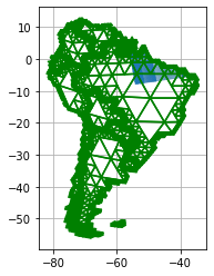
[13]:
joined = geopandas.GeoDataFrame(joined).set_geometry('trixels_left')
[14]:
fig, ax = plt.subplots()
ax.grid(True)

#ax.set_ylim(-10, 10)
#ax.set_xlim(-60, -30)
samerica.plot(ax=ax, color='green')
joined.plot(ax=ax, column='name')
[14]:
<AxesSubplot:>
[15]:
joined.head()
[15]:
| lat | lon | sids_left | Scan_Start_Time | Solar_Zenith | Solar_Azimuth | Sensor_Zenith | Sensor_Azimuth | Water_Vapor_Infrared | trixels_left | geometry_left | key_right | pop_est | continent | name | iso_a3 | gdp_md_est | geometry_right | sids_right | trixels_right | |
|---|---|---|---|---|---|---|---|---|---|---|---|---|---|---|---|---|---|---|---|---|
| 0 | -4.923621 | -33.579193 | 2833105768974759241 | 8.571477e+08 | 31.989999 | -96.479998 | 65.169999 | -99.029998 | NaN | POLYGON ((-33.74330 -4.97737, -33.50112 -4.989... | POINT (-33.57919 -4.92362) | NaN | NaN | NaN | NaN | NaN | NaN | None | NaN | None |
| 1 | -4.956750 | -33.786446 | 2833110603003551593 | 8.571477e+08 | 31.779999 | -96.449998 | 64.559999 | -99.009998 | NaN | POLYGON ((-33.88021 -4.75337, -33.98547 -4.965... | POINT (-33.78645 -4.95675) | NaN | NaN | NaN | NaN | NaN | NaN | None | NaN | None |
| 2 | -4.988602 | -33.986107 | 2833112722354712041 | 8.571477e+08 | 31.579999 | -96.419998 | 63.949999 | -98.989998 | 5.392 | POLYGON ((-34.09081 -5.17770, -33.84856 -5.189... | POINT (-33.98611 -4.98860) | NaN | NaN | NaN | NaN | NaN | NaN | None | NaN | None |
| 3 | -5.019270 | -34.178722 | 2833084363820531337 | 8.571477e+08 | 31.389999 | -96.389998 | 63.349999 | -98.969998 | 5.532 | POLYGON ((-34.09081 -5.17770, -33.98547 -4.965... | POINT (-34.17872 -5.01927) | NaN | NaN | NaN | NaN | NaN | NaN | None | NaN | None |
| 4 | -5.048833 | -34.364750 | 2833230005031123593 | 8.571477e+08 | 31.199999 | -96.359998 | 62.749999 | -98.949998 | 5.304 | POLYGON ((-34.33319 -5.16576, -34.22763 -4.953... | POINT (-34.36475 -5.04883) | NaN | NaN | NaN | NaN | NaN | NaN | None | NaN | None |
[ ]: